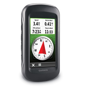
Take it hiking. Take it hunting. Take it on the water. Montana 650t features a bold 4 in. color touchscreen dual orientation display and TOPO U.S. 100K maps, supports multiple mapping options like BirdsEye Satellite Imagery and it has a 5 megapixel camera to boot. Montana has key features for the outdoors such as a 3-axis tilt-compensated compass and barometric altimeter. Buy the auto mount and a City Navigator NT® map, and it'll give you spoken turn-by-turn driving directions. It's big. It's versatile. It's tough. It earned the name Montana - the ultimate in touchscreen toughness.
Physical & Performance: |
| Unit dimensions, WxHxD: | 2.9" x 5.7" x 1.4" (7.48 x 14.42 x 3.64 cm) |
| Display size, WxH: | 2"W x 3.5"H (5.06 x 8.93 cm); 4" diag (10.2 cm) |
| Display resolution, WxH: | 272 x 480 pixels |
| Display type: | bright, transflective 65k color TFT, dual-orientation touchscreen; sunlight readable |
| Weight: | 10.2 oz (289 g) with included lithium-ion battery pack; 11.7 oz (333 g) with 3 AA batteries (not included) |
| Battery: | rechargeable lithium-ion (included) or 3 AA batteries (not included); NiMH or Lithium recommended |
| Battery life: | up to 16 hours (lithium-ion); up to 22 hours (AA batteries) |
| Waterproof: | yes (IPX7) |
| Floats: | no |
| High-sensitivity receiver: | yes |
| Interface: | high-speed USB and NMEA 0183 compatible |
Maps & Memory: |
| Basemap: | yes |
| Preloaded maps: | yes (topographic) |
| Ability to add maps: | yes |
| Built-in memory: | 3.5 GB |
| Accepts data cards: | microSD™ card (not included) |
| Waypoints/favorites/locations: | 4000 |
| Routes: | 200 |
| Track log: | 10,000 points, 200 saved tracks |
Features & Benefits: |
| Automatic routing (turn by turn routing on roads): | yes (with optional mapping for detailed roads) |
| Electronic compass: | yes (tilt-compensated, 3-axis) |
| Touchscreen: | yes |
| Barometric altimeter: | yes |
| Camera: | yes (5 megapixel with autofocus; automatic geo-tagging) |
| Geocaching-friendly: | yes (paperless) |
| Custom maps compatible: | yes |
| Photo navigation (navigate to geotagged photos): | yes |
| Outdoor GPS games: | no |
| Hunt/fish calendar: | yes |
| Sun and moon information: | yes |
| Tide tables: | yes |
| Area calculation: | yes |
| Custom POIs (ability to add additional points of interest): | yes |
| Unit-to-unit transfer (shares data wirelessly with similar units): | yes |
| Picture viewer: | yes |
Garmin Connect™ compatible (online community where you analyze, categorize and share data):
GPH49VQA4AER | yes |


Post a Comment